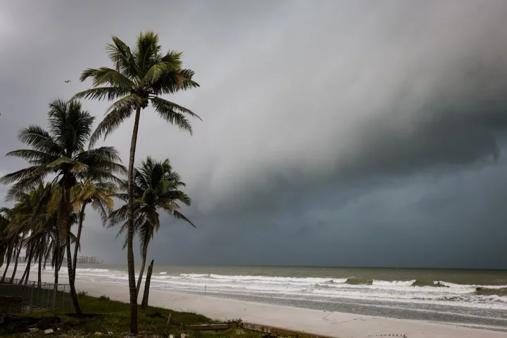
Hurricane Idalia is building strength in the Gulf of Mexico as it heads toward landfall Wednesday on Florida’s west coast, where it threatens to unleash floods and trigger blackouts.
Idalia’s winds topped 100 miles per hour Tuesday, making it a Category 2 storm on the five-step, Saffir-Simpson scale, the US National Hurricane Center said in a 5 p.m. advisory. Its winds could reach more than 125 mph, or Category 3 strength, as it comes ashore.
Idalia’s track has shifted slightly to the west, but as much as 15 feet (4.6 meters) of sea water could be pushed onshore north of Tampa and 6 feet could slosh across Tampa Bay.
The storm will likely strike north of heavily populated areas near Tampa and Clearwater, although changes to its path are possible. Idalia is forecast to reach the Big Bend coast south of Tallahassee Wednesday morning.
“Life-threatening storm surge and hurricane conditions” are expected along portions of the Gulf Coast of Florida Tuesday night and Wednesday, Robbie Berg, a senior hurricane specialist at the center, wrote in his forecast. “Rapid intensification is expected before landfall, and Idalia is forecast to be a major hurricane when it reaches the Gulf coast of Florida Wednesday morning.”
A storm surge of 10 to 15 feet could strike along the coast from Aucilla River to Yankeetown, Berg wrote.
The storm is currently moving over the extremely warm Loop Current, which will allow it to grow in strength.
Tampa International Airport is closed Tuesday. According to data from FlightAware, 794 flights in and out of Tampa and Atlanta have been canceled for Tuesday and Wednesday.
Rain should start to spread across Florida and winds will pick up in the Fort Meyers area tonight, said Tyler Roys, a senior meteorologist with commercial forecaster AccuWeather Inc.
If it reaches forecast Category 3 strength — with maximum sustained winds of at least 111 miles per hour — Idalia would be the first major hurricane to hit Florida since last September. That’s when Hurricane Ian struck the western part of the state as a Category 4 storm, killing at least 150 people and causing more than $112 billion in damage.
Depending on its exact track, Idalia could cause anywhere from $3 billion to $15 billion in damage and losses because much of the area in its potential path is sparsely populated, while other areas are built up, said Chuck Watson, a disaster modeler with Enki Research. If the storm hits 50 miles south of its current track, it would bring high winds to the Tampa-Clearwater area and push costs much higher.
Parts of Florida, southeast Georgia and the eastern Carolinas are likely to see as much as 8 inches (20.3 centimeters) of rain into Thursday, with up to a foot likely in some isolated areas, the hurricane center said.
If the storm continues along its current route, Idalia is expected to hit farther west than originally expected in an area known as the Big Bend. That area hasn’t seen a major hurricane since the 1800s, Florida Governor Ron DeSantis said during a press conference. As a result, officials said that evacuation orders for Idalia represented about a fifth of the people who were asked to evacuate during Hurricane Ian last year.
“You are going to see a lot of debris,” DeSantis said. “There are a lot of trees along that track. It will knock down trees, it will knock down power lines.”
DeSantis extended an emergency declaration to cover 49 counties, with mandatory evacuation orders for several on the Gulf Coast. President Joe Biden approved federal emergency declarations for Florida, allowing the Department of Homeland Security and the Federal Emergency Management Agency to coordinate relief efforts. Georgia Governor Brian Kemp also declared an emergency Tuesday.
Idalia is expected to stay in the eastern Gulf, missing most oil and natural gas platforms. But Chevron Corp. is transporting non-essential personnel from its Blind Faith and Petronius platforms in the Gulf, the company said in emailed statement. Martin Midstream plans to temporarily cease operations at its Tampa oil terminal.
Most of the key citrus areas in central Florida would not be seriously impacted, World Weather Inc. President Drew Lerner said. Florida is the top orange-juice supplier in the US.
After it crosses Florida, Idalia could bring heavy rain and storm surge along the coastline from Georgia to North Carolina, a situation that could be made worse by higher-than-normal tides brought on by Wednesday’s full moon, Roys said.
Barge traffic moving fuel along the US Gulf Coast to Florida is down, Ned Bowman, executive director of the Florida Fuel Marketers Association, said Monday. Meanwhile, demand is surging for gasoline as Floridians fill up for possible evacuations as well as for diesel for backup power generation, Bowman said.
Tampa and other regional ports are closed to inbound traffic, as is the Gulf Intracoastal Waterway. Some North Carolina ports also halted activity. Florida is mainly supplied via waterborne shipments from refiners in Texas and Louisiana.
--With assistance from Dan Murtaugh, Jim Wyss, Sheela Tobben, Chunzi Xu, Anna Jean Kaiser, Kevin Crowley, Immanual John Milton, Áine Quinn and Carolynn Look.
(Updates status in second paragraph.)
Author: Brian K. Sullivan, Mark Chediak and Brian Wingfield